The Blue Dot in Vegetation Mapping
Protected Plants Flora Survey Trigger Map
There has been a spike in “blue dot” enquiries on vegetation mapping.
Numerous requests have been raised about the “high risk area” trigger map under Nature Conservation Act 1992 (“NCA”) and Nature Conservation (Wildlife Management) Regulation 2006 and interactions with the Property Maps of Assessable Vegetation (PMAV) under the Vegetation Management Act 1999 (“VMA”).
Interaction between different legislation
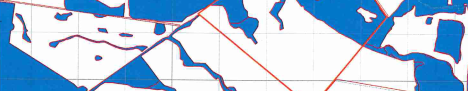
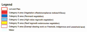
Where property is shown as ‘category X’ non-remnant vegetation in the Regulated Vegetation Management Map, registration of a PMAV should ensure this category of vegetation is “locked in”, subject to future legislative changes, should any occur.
Regulated Vegetation Management Map
However, where your land appears under a NCA trigger map as a high risk area for endangered, vulnerable or near threatened plant (“EVNT plants”) this map will neither take precedence nor be affected by the regulated vegetation mapping generated under the VMA. This is because the two Acts regulate different things and neither can be said to prevail over the other; the obligations upon owners and occupiers of land under the different Acts are independent of each other.
It is possible to have a PMAV that shows category X non-remnant vegetation on one map and be obligated to comply with the requirements under the NCA because of the presence of the “blue dot” trigger map on the same land.
Generally this principle applies if, for example, there were protected plants regulated under the Water Act 2000 or the Commonwealth’s Environmental Protection and Biodiversity Conservation Act 1999 (“EPBCA”). There are specific exceptions which are beyond the scope of this newsletter.
A PMAV will protect specific rights to clear non-remnant regrowth but will not limit or remove obligations to comply with other laws about protected vegetation.
Removal of a “blue dot”
A “blue dot” trigger map under the NCA is used to identify areas of land in which clearing would create a high risk of harm to EVNT plants. The mapping is used to signal to any user of the land that it is within a high risk area.
If a “blue dot” is shown over part of land you intended to clear or a suitably qualified ecologist should conduct a flora survey and produce a flora survey report.
A clearing permit is not required if the flora survey does not detect any EVNT plants in the clearing impact area or clearing will not occur within 100 metres of EVNT plants so that any potential impacts on EVNT plants will be avoided. However, an “exempt clearing notification” must be submitted to the Department of Environment and Science within one year of the survey being undertaken and at least one week prior to the clearing commencing.
Clearing that has complied with this process will not be subject to any further survey or approval requirements once clearing commences. Re-clearing or routine maintenance can be carried for up to 10 years after the original authorised clearing.
If a flora survey identifies the presence of EVNT plants in the clearing impact area, a clearing permit is required before any potential clearing can occur. The flora survey report, as well as an impact management report, will need to be included with the clearing permit application form, along with the payment of the application fee currently of $2,866.
A clearing permit authorises the clearing of an area of land rather than the clearing of an individual species of plant. Clearing that has complied with a permit will not be subject to any further survey or approval requirements once clearing commences. You can then carry out re-clearing or routine maintenance for up to 10 years after the original authorised clearing.
Compliance with the NCA regime for clearing in high risk areas does not mean that the “blue dot” will be removed from the map, as the mapping is used to identify EVNT plants “in the wild”.
The presence of these plants will still need to be brought to the attention any other users of the land, such as a State Government authority constructing public works, regardless of whether the Landholder has complied with obligations under the NCA regime.
Limitation on Mapping
It is interesting to note that the State still qualifies its mapping in relation to vegetation management to say that it is not accurate and should not be relied upon for any purpose. A typical disclaimer is:
This information provides advice of a general nature only and should not be relied upon as legal advice.
PUBLISHED 8 APRIL 2018.