CSG – Deviated Drilling & Subsidence
This edition of our Landholder Newsletter covers CSG Deviated Drilling, CSG related subsidence, and Regional Interests Development Approvals in Priority agricultural areas & Strategic cropping areas.
[Aug 2023]
Background
The Queensland government has fined Arrow $1m for breaches of land access rules over four years, after an investigation into allegations the company drilled diagonally beneath farmland without notifying the landholders.
Unsurprisingly, history repeats itself.
“Early in 1873 the Appellants who were working coal in land adjoining to Watt’s Grant found that their workings were approaching the boundary between the two properties and so informed the then trustees of Henry Osbourne’s will, and entered into negotiations with them for the purpose of obtaining a lease of Watt’s grant. These negotiations fell through but the Appellants proceeding secretly with their workings entered upon Watt’s claim and between the years 1878 and 1880 removed the coal from under some 14 acres of such land. The trespass was distinctly shown upon the Appellants own working plan. It was committed underground, and committed wilfully.”2
The conduct of the coalminer founded a successful court action against it based upon that trespass.
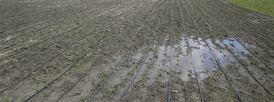
Surface subsidence has been a known risk that governments and the gas industry have been willing to take in relation to your land.
In the Geoscience Australia report dated 29 September 2010 the report summary provided:
Based on our assessment of the geological and geotechnical information provided, and relevant information from other sources, we consider that there is a likelihood of subsurface subsidence, and that this could result in surface subsidence.
Based on the estimated magnitude of the subsidence (in the order of centimetres or tens of centimetres), and with reference to subsidence assessments for CSG activities in similar geological environments elsewhere, we consider that the risk of impact to the surface water and shallow groundwater systems is very low.
We suggest that the monitoring activities currently proposed by 2 of the proponents should be strengthened by assessing the formation at the land surface as well as in the aquifers and coal seams.
In the Surat Gas Expansion Project (EPBC 2010/5344) Approval dated 19 December 2013 condition 13(g) required a program to monitor subsidence impacts to be submitted prior to commencement.
The Gasfields Commission Report, Regulatory review of coal seam gas-induced subsidence dated November 2022 on surface subsidence, confirms the linkage between surface subsidence and the CSG industry.
The independent Office of Groundwater Impact Assessment (OGIA) currently produces regional scale predictions and a monitoring framework for CSG-induced subsidence in the Underground Water Impact Report 2021 for the Surat Cumulative Management Area (UWIR 2021). The assessment has confirmed that CSG-induced subsidence has occurred and is predicted to occur in the future based on current CSG development patterns.
AND
In this instance, CSG-induced ‘subsidence’ is described as a component of ground movement that is induced by CSG depressurisation. In the context of CSG activities, it occurs due to lowering of pressure in the underlying coal seams which, in turn, allows the seams to compress under the weight of the overlying formations. The resultant ‘ground movement’ at the land surface is known as CSG-induced subsidence.
Queensland Government Response May 2023
The Queensland Government Response to GasFields Commission Queensland (GFCQ) recommendations on the regulatory review of CSG-induced subsidence dated 3 May 2023 provides:
Modelling and monitoring to date has identified that CSG-induced subsidence has and will continue to occur.
To address gaps in the current regulatory framework, the Queensland Government will establish and implement an adaptive management framework in the Mineral and Energy Resources (Common Provisions) Act 2014 that assesses impacts from CSG-induced subsidence, and provides an appropriate remedy for affected parties, including those parties off-tenure.
An adaptive management regime has limitations and should only be used in certain circumstances. Those circumstances were summarised by the Supreme Court in New Zealand3 as:
The Court particularly considered whether adaptive management could legitimately be adopted to give effect to the precautionary approach, and Glazebrook J identified four factors that should be assessed to decide:
(a) the extent of the environmental risk (including the gravity of the consequences if the risk is realised);
(b) the importance of the activity (which could in some circumstances be an activity it is hoped will protect the environment);
(c) the degree of uncertainty; and
(d) the extent to which an adaptive management approach will sufficiently diminish the risk and the uncertainty.
Glazebrook J regarded the test contained in (d) as the vital one because it addresses whether the adaptive management regime can deal with risk and uncertainty surrounding the activity.
The scientific predictions of the risk being low in 2010 do not bode well for acceptance of further scientific predictions going forward.
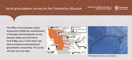
We note that Arrow Energy have notified an intention to undertake a fly over to obtain further information.
OGIA has commissioned a flyover survey.
The requirement to monitor under the 2013 EPBC Act approval should provide meaningful base data that should identify current impacts. We are concerned that there will be a scale issue with any base data so that it will provide limited use in assessing on farm impacts. A right to information application in relation to that data could confirm whether it was completed and whether it will be of any value to you and your land.
We also consider there is a need to determine the diminution in value to your land if affected by subsidence and other potential compensation such as the increased cost of Scan the QR code below to read more about OGIA online. 1 farm management.
REGIONAL PLANNING INTERESTS ACT 2014
The Regional Planning Interests Act 2014 (Qld) (RPI Act) identifies its purpose as protecting economic, social and environmental prosperity by giving effect to matters of state and regional interest4 which include priority agricultural areas and strategic cropping areas amongst others.5
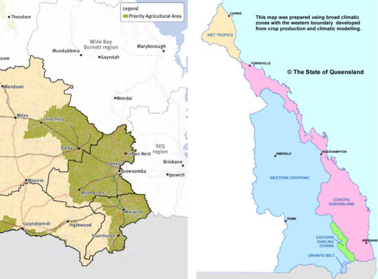
Priority agricultural areas (PAA) are identified on maps in a regional plan as a priority agricultural area.6
The Darling Downs Regional Plan identifies one PAA stretching from Chinchilla to Stanthorpe. (The Example).
Strategic cropping areas (SCA), identified below, include areas of land that are highly suitable for cropping due to the land’s soil, climate and landscape features.
Regional Interest Development Approvals
Under section 19 of the RPI Act, resource activities must not be carried out unless there exists a Regional Interests Development Approval (RIDA).
A RIDA is an approval for carrying out a resource activity “in an area of regional interest” given under section 53 RPI Act.7
RIDAs are being sought by resource proponents over a small number of lots.
Exemptions
Exemptions apply to the requirement to obtain a RIDA under Part 2, Division 2 of the RPI Act which is headed “Exempt resource activities”.
Under section 22 if a conduct and compensation agreement is entered into (irrespective of what is covered in it), it has been complied with, the activity is not likely to have a “significant impact” on the PAA and the activity is not likely to have an impact on land owned by a person other than the landowner, a RIDA is not required.8
If the activity is carried out for less than one year a RIDA is not required.9
Section 24 applies if there is a pre-existing resource activity that was commenced lawfully. It may continue without further approval in relation to the “location, nature or extent of the expected surface impacts” of the activity and where information in support of the gaining of the resource or environmental authority identified the “location, nature and extent of the expected surface impacts of the activity”.10
It is important to note this only provides an exemption in relation to “expected surface impacts”.
Regional Planning and State Significance
The Example identified in the regional plan which substantially includes the Condamine Alluvium should be considered on a wholistic basis.
Given the protections under the RPI Act are in relation to matters of State and regional significance, the piecemeal nature of applications for a RIDA over small groups of individual lots seems to defeat its purpose.
The cumulative impacts of multiple RIDAs on the Example area in conjunction with any exemptions applicable to the Example area ought to be assessed in relation to the whole of the Example area.
The following provisions support that broader assessment:
- Section 16 requires “an assessment of the extent of the expected impact of the activity on the area”;
- Section 17 requires a consideration of a regulated activity and whether it will “have a widespread and irreversible impact on the area of regional interest”;
- Section 29(b) requires a report “assessing the resource activity or regulated activity’s impact on the area of regional interest”;
- Section 49(1)(a) requires the chief executive to consider “the extent of the expected impact of the resource activity or regulated activity on the area of regional interest”; and
- Section 50(2)(b) requiring a condition to “be reasonably required to manage the impact of the activity on an area of regional interest”.
Those sections do not refer to the assessment for part of the area but rather they consider the assessment on the area. A small number of CSG wells on a small number of lots will not have any meaningful impact on the whole of the area or at all.
If the assessment was intended to be limited to piecemeal applications, it would fail to achieve the protection of the Example area of state and regional significance.
Perhaps an application should be required for the whole of the Example area to allow a consideration as to what percentage of the Example area of State interest that may be adversely impacted.
Deviated Drilling
The application for a RIDA is required to include in the property description the land the subject of the approval.11
Deviated drilling from one lot into an adjoining lot requires each of the landowners to be treated as “owners”.12
There is a requirement to give the owner a copy of the application.13
There is a requirement for the applicant for a RIDA to give the owner notice about the application.14
The process outlined above makes it more likely that an owner would be in a position to make a submission which is a matter that must be considered by the assessing agency.15
A copy of the decision notice must be given to the owner of the land.16
A RIDA attaches to the land despite any change in the land ownership or occupation.17
There are three (3) consequences of significance that flow if the process has not been followed in relation to deviated drilling onto adjoining land:
- the decision-maker may not be afforded the benefit of receiving and considering a submission from the owner in relation to the activity;
- the land should have been included in the application; and
- the land should be subject to the decision notice which attaches to it and binds successors in title.
Appeal or Originating Application
Appeal rights to the Planning and Environment Court are given to both an owner and an “affected landowner” about a RIDA.18
An appeal should be commenced within 20 business days after receipt of the notice by an owner or within 20 business days after the decision was published by the affected landowner.
In addition to appeal rights the court has power to make declarations about matters done, to be done or that should have been done under the RPI Act.
Failure to include adjoining land in an application for a RIDA where deviated drilling is proposed may be subject to review under section 78 of the RPI Act by way of originating application.
Who to Contact
Should your land be within the areas identified as PAA or SCA and you have concerns about the impacts of deviated drilling under your land or subsidence on your land, please contact us. We can also assist you in circumstances where deviated drilling has taken place under your land and you have not been notified of these activities.
This information provides advice of a general nature only and should not be relied upon as legal advice.
If you have any questions, please do not hesitate to contact Lestar Manning, Cameron Martin & Matt Patterson.
REFERENCES
1 Definition – to stray especially from a standard, principle, or topic. deviating from the subject: to depart from an established course or norm, a flight forced by weather to deviate south.
2 The Bulli Coal Mining Company v Patrick Hill Osborne and another (New South Wales) Privy Council, March 11, 1899
3 Sustain Our Sounds Inc v New Zealand King Salmon Co Ltd [2014] 1 NZLR 673
4 Section 3 RPI Act
5 Section 7 RPI Act
6 Section 8 RPI Act
7 Section 16 RPI Act
8 Section 22 RPI Act
9 Section 23 RPI Act
10 Section 24 RPI Act
11 Section 29 RPI Act refers to “approved forms” and the approved form under section 94 at item 1 requires a description of the land.
12 The Bulli Coal Mining Company v Patrick Hill Osborne and another (New South Wales) Privy Council, March 11, 1899
13 Section 30 RPI Act
14 Section 35 RPI Act
15 Section 41 RPI Act and then section 49 RPI Act for the decision
16 Section 51 RPI Act
17 Section 58 RPI Act
18 Section 71 & 72 RPI Act
19 Section 73 RPI Act